Last month we had a mini-adventure in Northumberland – we walked Isaac’s tea trail. Finally we’ve got round to adding a page about it to this website – hope you enjoy reading about it.
After a very long break – it felt good to get back outdoors last weekend! Two days walking in the surrey hills, the first from Ockley northwards. We were aiming for Friday Street, but only got as far as Leith Hill, where we rewarded ourselves with a mug of tea with a view (purchased from the tower) and headed back south.
The second day we did a bit more of the Greensands Way. We started at Hurtwood Car Park no 1 and headed east towards Leith Hill. We didn’t go up this time, but then headed north over Abinger Common and then back round via Holmbury St Mary and through the Hurtwood. Here’s our route. The views from Holmbury Hill at the start are spectacular. However, car park no 1 is slightly terrifiying – the steep sandy entrance is severely rutted and I’ve no idea how poor Nessie made it up to the top!
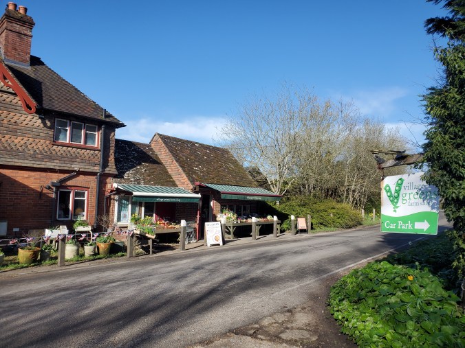
In between the two walks, I did my first night in the van. A BritStop at Village Greens Farm Shop, Ockley. A bit of a trial run getting ready for the season ahead. Before I set out I refilled Nessie’s water tank and got the pump working, and one of the gas rings was working – but I could not get the other gas ring to stay alight nor can I get the heating to work!! That said, if I can do without heating this weekend when the temperatures was 1C overnight, then probably doesn’t matter (and I’ve got good at ignoring the light that’s been flashing for months!!). I just wore a lot of layers – 3 thermals and a jumper for sleeping, and had my hot water bottles and I wasn’t cold in the night (well only my nose when it poked out of my sleeping bag cacoon!). When I woke up in the morning and tried to look out the window, there was ice on the inside and outside of the van!
Dinner was beef stroganoff (which it turns out is fairly straightforward to cook on one gas ring!) followed by shop-bought apple pie and some custard. Given that the days are still relatively short, I thought I’d have lots of time to kill and might do some sorting out of the various cupboards in the van, but I didn’t! What with cooking and an audiobook and a knitting project, the evening passed quickly and happily.
We’re conscious we haven’t blogged for a while. Sorry!
We have done a few more sections of the Greensands Way, we’ve just not been very good about telling you!
But for the new year we’ve another challenge we’re tackling simultaneously – walking the River Meon. You can read about more about this, and our first section where we went to find the river’s source, on our new River Meon walk page.
Gven as we had to postpone our planned camping trip, we decided to tackle the next section of the Greensands Way instead. We walked over 8 miles, but we only made 2 miles of progress along the Greensands Way as that pesky little road called the A3 was in our way! Basically our route as all around crossing the A3!
Who would have thought a short walk in the Surrey countryside could take in so much, but we came across all this and more on the last section of the Greensands Way we walked. Read about it here.
Confesssion… it was actually a little while ago we walked this section. We had hoped to camp at the coast this weekend, but the high winds meant this wasn’t sensible. Instead, we are walking the next part of the Greensands Way, which made us realise we are behind with the blogging!!
At long last we completed the last section of the Wayfarers Walk!! We set out shortly before lunchtime from the car park at Southmoor nature reserve, with our sights set on the Coal Exchange pub for lunch, just 3 miles away. It didn’t prove quite that simple… read more about our adventure.
As you will know, we are currently walking the Greensands Way. We’d only walked two sections and got as far as Thursley when we got confused – the Greensands Way appeared to go both west and east! As far as we can work out, there is an additional ‘spur’ of the path to Farnham, whilst the official route continues east.
Not wanting to miss out on anything, and curious to walk on Thursley Common which we had heard about but never visited, we thought we’d first walk this spur before continuing with the main path.
Turns out Thursley and Hankley Commons are both interesting environments to explore – read about our walk here.
The next section of the Greensands Way took us round the edge of the Devil’s Punchbowl – an area which, in addition to it’s folklore and name, does have a lot of grim history!
From time to time we like to hear about how some of our friends have embraced their inner goat.
Where have you been walking recently?
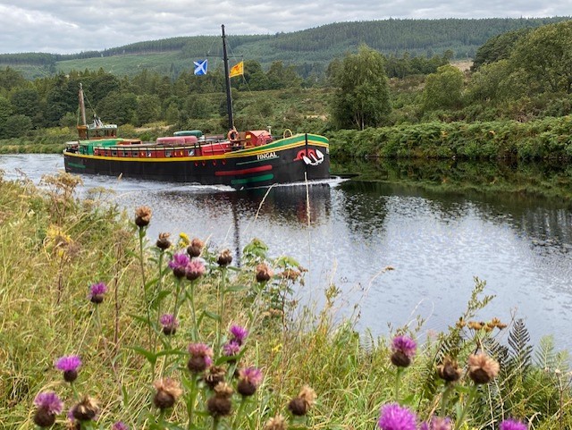
The Great Glen Way from Fort William to Inverness
How long is that path?
In theory it’s 75 miles but there are places where you can take either a higher or lower level walk and on occasions I detoured to get a better view from up a nearby hill so I took some 80 miles
How many days did you split it over?
The walk took a full week but there’s also a lot of travelling to get to the start and back home!
What did you do for accomodation?
The accommodation was a real highlight of the trip – a large, old barge. Each morning after breakfast the boat and 7 walkers departed and met up again early afternoon. There was a crew of 4 – Captain, Guide, Cook and a man who did all the other jobs necessary on a barge.
What is the scenery like?
Stunning scenery especially the 25 miles or so along Loch Ness made all the better given the wonderful weather and absence of midges
What was your highlight from the walk?
Most of the other walkers were very fit and wanted to walk fast. A couple struggled a bit with this so spent a couple of days on the barge. The result was that I spent most of the walk alone with the professional Guide who was a great guy full of stories about his experiences guiding in the Alps and who was very knowledgeable about the countryside we were passing through.
Any lowlights?!
There were no real problems on the trip but it’s worth bearing in mind that you are likely to be in close company for a week with a group of people you’ve never met before. You just have to hope you all get on well together!
Would you recommend this walk to others? If so, any tips or things you’d do differently?
This is a great way to walk if you don’t want to carry your stuff around with you or worry about accommodation and where to eat each evening. The bedrooms were en suite with a wonderful, powerful shower and the food was excellent.
By the end of our 5 days walking in the Mendips, our bodies had got used to the increased activity and the walking and carrying got easier. We were keen to keep up the steps and so we’ve started our next challenge already, the Greensands Way. We’re going to do this route in circular day walks, the same approach as the Wayfarers. It’s pretty long, so it should keep us busy for a while!
We walked the first section last week… and went in search of King Kong!