We’re conscious we haven’t blogged for a while. Sorry!
We have done a few more sections of the Greensands Way, we’ve just not been very good about telling you!
But for the new year we’ve another challenge we’re tackling simultaneously – walking the River Meon. You can read about more about this, and our first section where we went to find the river’s source, on our new River Meon walk page.
Gven as we had to postpone our planned camping trip, we decided to tackle the next section of the Greensands Way instead. We walked over 8 miles, but we only made 2 miles of progress along the Greensands Way as that pesky little road called the A3 was in our way! Basically our route as all around crossing the A3!
Who would have thought a short walk in the Surrey countryside could take in so much, but we came across all this and more on the last section of the Greensands Way we walked. Read about it here.
Confesssion… it was actually a little while ago we walked this section. We had hoped to camp at the coast this weekend, but the high winds meant this wasn’t sensible. Instead, we are walking the next part of the Greensands Way, which made us realise we are behind with the blogging!!
At long last we completed the last section of the Wayfarers Walk!! We set out shortly before lunchtime from the car park at Southmoor nature reserve, with our sights set on the Coal Exchange pub for lunch, just 3 miles away. It didn’t prove quite that simple… read more about our adventure.
As you will know, we are currently walking the Greensands Way. We’d only walked two sections and got as far as Thursley when we got confused – the Greensands Way appeared to go both west and east! As far as we can work out, there is an additional ‘spur’ of the path to Farnham, whilst the official route continues east.
Not wanting to miss out on anything, and curious to walk on Thursley Common which we had heard about but never visited, we thought we’d first walk this spur before continuing with the main path.
Turns out Thursley and Hankley Commons are both interesting environments to explore – read about our walk here.
The next section of the Greensands Way took us round the edge of the Devil’s Punchbowl – an area which, in addition to it’s folklore and name, does have a lot of grim history!
From time to time we like to hear about how some of our friends have embraced their inner goat.
Where have you been walking recently?
The Great Glen Way from Fort William to Inverness
How long is that path?
In theory it’s 75 miles but there are places where you can take either a higher or lower level walk and on occasions I detoured to get a better view from up a nearby hill so I took some 80 miles
How many days did you split it over?
The walk took a full week but there’s also a lot of travelling to get to the start and back home!
What did you do for accomodation?
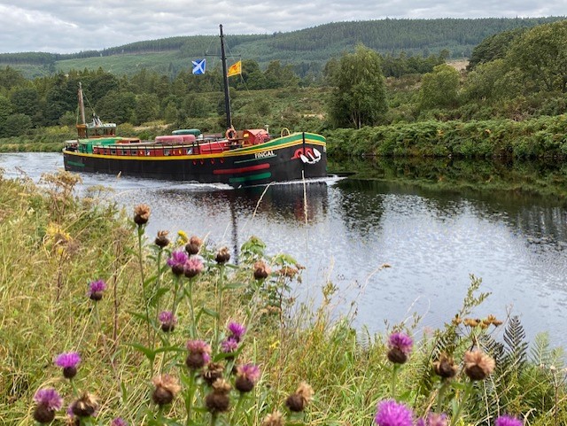
The accommodation was a real highlight of the trip – a large, old barge. Each morning after breakfast the boat and 7 walkers departed and met up again early afternoon. There was a crew of 4 – Captain, Guide, Cook and a man who did all the other jobs necessary on a barge.
What is the scenery like?
Stunning scenery especially the 25 miles or so along Loch Ness made all the better given the wonderful weather and absence of midges
What was your highlight from the walk?
Most of the other walkers were very fit and wanted to walk fast. A couple struggled a bit with this so spent a couple of days on the barge. The result was that I spent most of the walk alone with the professional Guide who was a great guy full of stories about his experiences guiding in the Alps and who was very knowledgeable about the countryside we were passing through.
Any lowlights?!
There were no real problems on the trip but it’s worth bearing in mind that you are likely to be in close company for a week with a group of people you’ve never met before. You just have to hope you all get on well together!
Would you recommend this walk to others? If so, any tips or things you’d do differently?
This is a great way to walk if you don’t want to carry your stuff around with you or worry about accommodation and where to eat each evening. The bedrooms were en suite with a wonderful, powerful shower and the food was excellent.
By the end of our 5 days walking in the Mendips, our bodies had got used to the increased activity and the walking and carrying got easier. We were keen to keep up the steps and so we’ve started our next challenge already, the Greensands Way. We’re going to do this route in circular day walks, the same approach as the Wayfarers. It’s pretty long, so it should keep us busy for a while!
We walked the first section last week… and went in search of King Kong!
Now that we’ve recovered from our adventure, we thought you might be interested in our reflections – espcially if you are considering doing this walk yourself.
As ‘long distance’ walks go, it’s not too long – which makes it very achievable if you’ve only got a week’s holiday. It also has good train connections at Frome and Weston-super-Mare, which is an important consideration.
We walked from East to West – and we’d recommend doing it that way round. A lot of the guides suggest the other way, but we’re not sure why. The West Mendips section of the path is more scenic than the East Mendips section, so this way the views get better and better as you go. And reaching the sea feels like a good end point to aim for – you can’t go any further!! It’s a shame that there isn’t a properly marked end point to have your photo by, but the sea is a good backdrop to a selfie!
If you haven’t enough days to do it all, the West Mendips path which starts at Wells is a good option – this takes in the best bits and the most spectacular views towards the sea. You could do that in 3 days.
We planned our sections around where there were suitable places to stay overnight. It turned out we started with a long day and then alternated shorter and longer days. This was really helpful both psychologically and physically for our out-of-practise bodies. We’d definitely try to plan future walks that way.
The table below sets out our accomodation plan …. & equally important our food plan! (We’ve given links to the places we’d be happy to recommend).
Walking from Uphill into Weston-super-Mare isn’t too far (2 miles), we walked along the beach, but you could also get there via roads. We booked our train for early afternoon to allow us some time in Weston. We enjoyed our fresh donut reward and a coffee on the sea-front and tried our luck on the 2p machines at the pier! We also enjoyed wandering round exploring the town and taking in the sea views, but we hadn’t fully thought through that we’d have our big bags with us to carry round all day.
We seemed to carry a lot of stuff. It must be perfectly possible to do it with less, but we enjoyed our neverending snack supply and having our books and crochet project to entertain us in the evenings. We should have done our final pack together as we could have shared some items, but overall we seemed to have the things we needed and managed to carry our packs ok.
We took paper copies of the OS maps 142, 141 & 153. Although the route is way marked with blue arrows, they aren’t reliable enough to be able to find your way without a map. It’s also worth noting that although our maps were new, there were some points where the route had been altered, or an alternative provided, which wasn’t on our map. The OS app was helpful in these circumstances.
Overall we’d recommend this walk – do let us know how you get on if you try it yourself.
We slept well in the Premier Inn and so we didn’t make an early start – we waited for the rain to come on!!
It rained to varying degrees throughout the day, but we still had a pleasant day’s walking. The countryside today was more open with the first part of our walk traversing downland. We were pleased to discover we didn’t need to climb Crook Peak and instead descend down to the roar of the M5!
We were ready for a coffee break and were relieved to find St Andrews Church, Loxton was open and we could shelter from the rain and enjoy our elevenses in the dry.
From there it was up again and following a straight path most of the way to the viewing point for our lunch. We hadn’t found any shops to buy sandwiches, so lunch today was cuppa soups & cream crackers!
The route then went along Roman Road and we realised that if only we’d waited a bit longer for lunch, we could have had an even better view sitting on a bench by Bleadon Hill golf course.
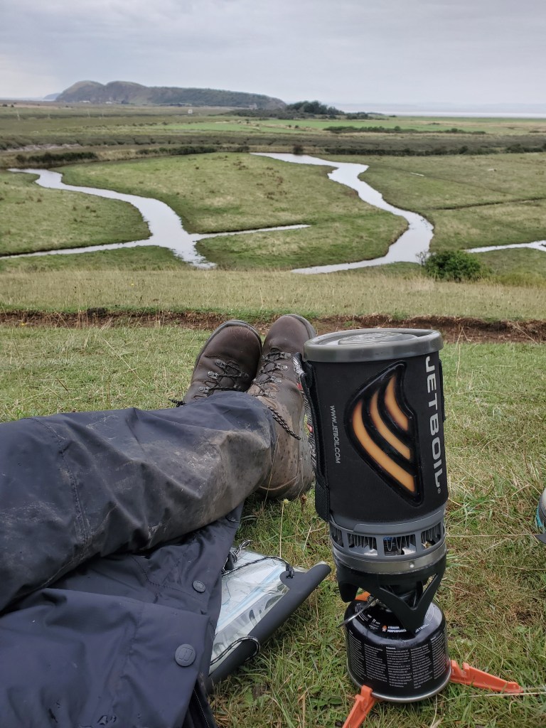
The route gradually became more built up as we neared Weston-super-Mare. The last section of our walk was across Bleadon Levels, an estuary landscape with views out across the marshes.
We had made good time, so we could stop for a tea break at Uphill Nature reserve overlooking the marshes & marina.
From there, it was a short walk down into Uphill, but finding the official end of the walk was trickier. Turns out there was just a plaque on the sluice gate wall over grown by brambles! A bit disappointing after all those miles, but we did make our own official end point by going down onto the beach.
Today’s walk was 11 miles. We rewarded ourselves with dinner in the Ship Inn and a good night’s rest in ‘Rooms @ Uphill’.