Let’s get the confessions over straight up. We did skip a tiny bit of the path and missed out the bit of the Wayfarers that crossed Furzeley Golf Club! But we were back on track before Closewood Farm. We then followed the Wayfarers path very religiously even past all the back gardens at Widley. If you are doing this bit you might prefer to walk past the fronts of the houses as the path was hard going because it was very overgrown! We did chat to one lady in her garden who said the path had been very boggy as water had been allowed to overflow from the nearby reservoir recently. Maybe that’s why the plants had grown so vigourously?
We were on a mission to get to Portsdown for our lunch. A friendly farmer had told us that the burger van there was particularly good, but we had packed our sandwiches so we were just after the view! It didn’t disappoint!
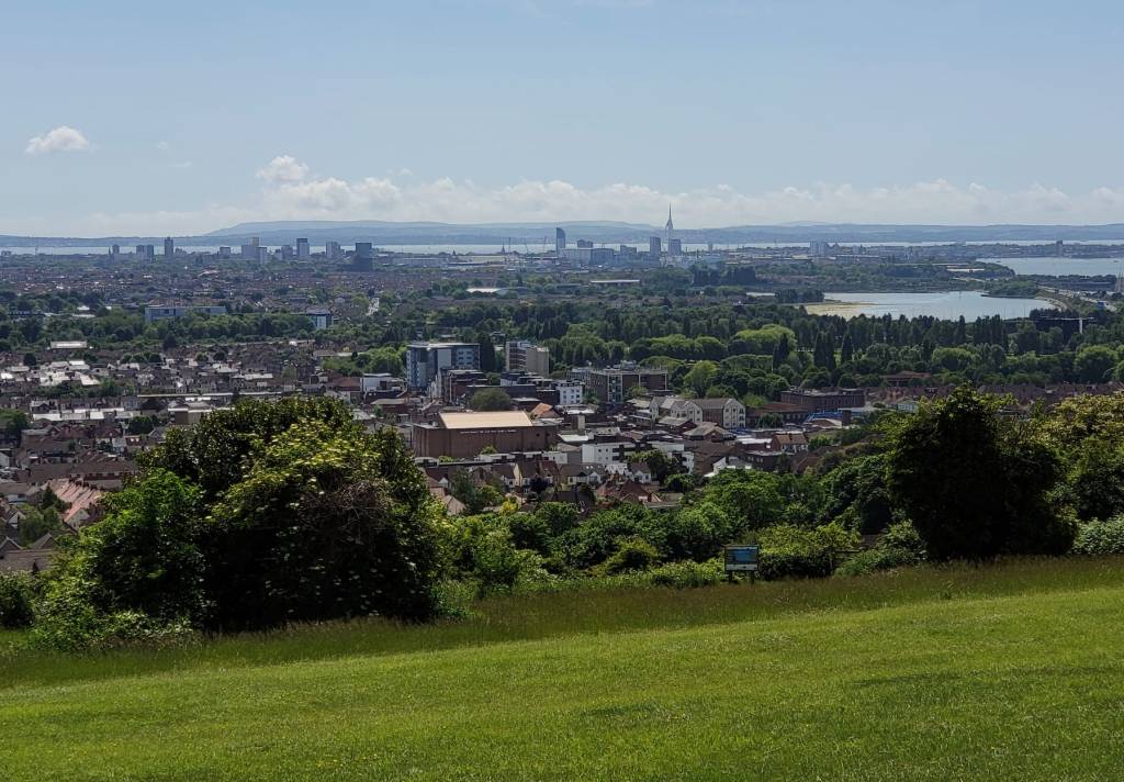
Finally we could glipse the sea and feel that we were nearly there on this long adventure! It was a very hot, sunny day, so we treated ourselves to an icecream for pudding and sat and admired the view a bit longer.
Portsdown’s name originates from Portus (meaning Port) and Dun (meaning hill). It is a chalk hill, part of the same strata which forms the South Downs to its north and the chalk outcrops on the Isle of Wight to its south. The down was grazed until shortly after World War Two, after which scrub started to encroach. However since the 1990s it has been managed more carefully and the downland restored.
Keen to seek out shade we walked through a small woodland and discovered it was actually a memorial for the Falklands War.

We carried along one of the lower paths on the slope, but made our way up to be able to see Fort Widley. Along with several other ‘Palmerston Forts’ along Ports Down, it was built in the 1860s in response to the perceived threat of a French invasion. The forts were intended to defend Portsmouth Dockyard. During the Victorian period Fort Widley accomodated infantry units in the barracks. During the First World War it was used as a transit depot. During the Second World War it was modified to provide more accommodation. In 1952 the fort became home to a bomb disposal squadron and a year later an emergency civil control centre for Portsmouth was constructed in the fort’s magazine. The fort was sold to Portsmouth City Council in 1972 and in 1990 the fort became an activity centre. It is currently used as an equestrian centre and was a bit of a disappointment to us as all we could see were the imposing walls! It seems that there were interesting tunnels under our feet, but they are not open to the public.
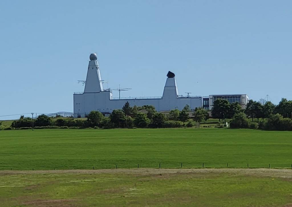
We followed the Pilgrims’ Trail to keep off the main road. Here we got some better views of a curious place that looks like a ship built on the land! It is the Maritime Integration and Support Centre (MISC), a naval research centre.
We enjoyed walking through a shady coppice, even if it was a bit of a circuitous path, and then made our way towards Southwick. We were disappointed that a big wall meant we were not to be able to see the Southwick Park Lake, which looks so nice on the map!
We got to Southwick just in time, as the tearoom was about to close! They had sold out of cake (it did look like it had been good!), but it was still nice to rest our feet and have a cuppa in the tea garden.
Refreshed we had a nosey around the village. We started off by popping into the church, where we found a leaflet that told us about lots of other historical landmarks in the village. The village is still almost entirely owned by the Southwick Estate – which explains why all the houses, have dark red-painted front doors, as it is a condition laid down in the tenancy agreements.
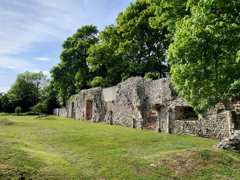
We also spotted on the map a footpath leading to Southwick Priory, which we’d not been able to see from the road because of that big wall! We added quite a few more steps to our route by following the track to see the ruins so we thought we’d better take a picture of it!
We retraced our tracks back through the village and out the other side, until we could turn into Place Wood. We didn’t see any particular evidence of Place Wood Castle, although the ground was quite undulating. The castle was originally an earth and timber ringwork fortification, probably built as part of Henry I’s campaign to isolate and defeat the Earl of Shrewsbury who opposed his appointment as king in 1101. The castle was sited to overlook the Chichester to Bitterne Roman Road that was still in use during the twelfth century.
The last bit of our route took us down Sheepwash Lane, back to find our cars at the car park on Furzeley Road.
This circuit was 10.5 miles (not including the detour to the priory!).
